Research Projects

Research Projects

Research drone with applications flowchart

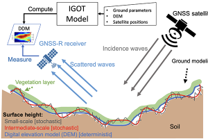
Software Defined Radar

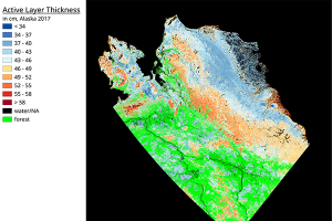
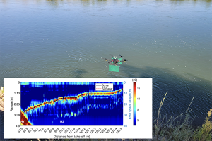
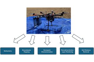
Software-defined radar (SDRadar) is a highly reconfigurable radar based on software-defined radio technology that can be adopted for different applications. Our radio-frequency system-on-chip (RFSoC) based SDRadar is a low-cost solution for ultra-wideband and multi-band applications. It can be used in monostatic and multistatic configurations for different environmental monitoring purposes including soil moisture retrieval, groundwater detection, permafrost active layer mapping, riverbed bathymetry, and snow characterization.

Map showing Alaska active layer thickness

Permafrost

We have pioneered the retrieval of arctic permafrost active layer soil profile properties, such as active layer thickness (ALT) and soil moisture profiles, using the NASA/JPL airborne polarimetric P-band and L-band UAVSAR, separately and in combination with each other. Our work has shown spatial heterogeneity of ALT and its dependence on landscape properties, as well as its interannual variability in the context of longer-term climate trends. In parallel, we are developing a UAV-based ground-penetrating radar system to map ALTand soil moisture in permafrost with high (1-5 m) spatial resolution. Flying close to the surface boosts sensitivity beyond satellite and aircraft methods. Our processing pipeline improves radargrams via distortion correction, clutter suppression, and super-resolution range profiling.

Research drone hovering over river water and map showing river depth

Bathymetry

River bathymetry, or submerged topography of riverbeds, is a critical variable in many hydrological, operational, and environmental applications. We have developed an ultra-wideband (UWB) SDRadar system coupled with a custom in-house low frequency antenna and a series of post-processing algorithms to provide a low-cost and accurate solution for measuring the bathymetry of rivers. This system gives us the capability to map both shallow and deep sections of the river with excellent resolution and accuracy.

Research drone hovering on a platform

Snow 

In this project we have built a field-ready UAV based software-defined radar (SDRadar) system that measures snow depth and snow layer structure to estimate snow water equivalent (SWE) and assess avalanche risk. Field campaigns show accurate depth retrievals and clear layer detection.

Flowchart of soil moisture wireless sensing network

SoilSCAPE

The Soil moisture Sensing Controller and oPtimal Estimator (SoilSCAPE) technology, developed in our group, uses wireless sensor networks to collect high-temporal-resolution soil moisture data across sites in the United States and New Zealand. These measurements support open-access research and help validate satellite-based products, such as those from the NASA AirMOSS, CYGNSS, and SMAP missions, linking local observations with regional and global soil moisture estimates. SoilSCAPE data are available in real time from our USC gateway, from the ORNL DAAC, and from the International Soil Moisture Network (ISMN).

A multi-panel diagram illustrating a human motion recognition system. On the left, a back view silhouette of a person shows labeled transmitter (TX1–TX8) and receiver (RX) sensor placements on the arms, waist, and legs. In the center, a simplified stick-figure skeleton displays motion capture markers labeled M1–M15 at the head, shoulders, elbows, hips, knees, and feet. On the right, a 3D skeletal model highlights joint angles at the lower leg and ankle (e.g., θ_TX8 and related components). Along the bottom, time-series motion signals (“MI-motion data”) are shown feeding into a deep recurrent neural network (RNN), which outputs predicted activity labels such as Walk, Run, and Jump.

Motion Tracking using Magnetic Induction Sensors

In this project we are using magnetic induction (MI) sensors to track human body movements. This system offers a low-power, secure, and accurate alternative to conventional wearable sensors by capturing relative motion through MI-based coil networks.

Flowchart of IGOT bistatic scattering model

GNSS Reflectometry

We use Global Navigation Satellite System (GNSS)-reflectometry (GNSS-R) to estimate land surface properties from satellite signals, such as GPS, reflected off the ground, with a focus on the NASA CYGNSS mission. Our improved geometric optics with topography (IGOT) model, which accounts for topographic relief, can be used in the presence of both light vegetation and forests with vegetation attenuation and volume scattering, showing good agreement with CYGNSS observations. Building on this modeling, we develop physics-based and machine learning algorithms to retrieve soil moisture and related geophysical variables at scale.

Microwave thermal imaging setup

Real-Time Microwave Imaging of Thermal Therapies

We have built a GPU-accelerated 3D microwave imaging system that reconstructs tissue permittivity and conductivity in near real time from S-parameter data using an enhanced variational Born iterative method with real/imaginary separation. This system enables intra-operative frame-level monitoring of thermal dose for image-guided assistance during thermal treatments of lesions.

Map showing Alaska wetlands

Environmental Mapping

We create multi-scale environmental maps from microwave airborne and spaceborne remote sensing platforms, including SARs, GNSS-Reflectometry, and radiometers. , Our team builds classifiers, change-detection tools, machine learning, and physics-based models to retrieve surface to subsurface properties such as soil moisture, wildfire burned areas, wetlands, permafrost active layer thickness, and soil organic carbon, supporting actionable decisions for forests, agriculture, and Arctic-boreal region infrastructure and conservation.

Flow chart of soil moisture retrieval from radar imagery

Subsurface and Subcanopy Soil Profile Characterization

Our group has established a long track record of expertise in forward and inverse scattering models for subcanopy and subsurface characterization for use with synthetic aperture radar (SAR) with various frequencies and polarizations. We have used polarimetric P-bandand L-band radar, separately and jointly, for retrieving vegetation properties and surface-to-root-zone profiles of soil moisture, for a variety of landscapes. We have developed various retrieval methods, including physics-based global and hybrid optimizers, as well as physics-trained AI methods, to perform high-accuracy retrievals for a range of terrains, including managed and natural forest, shrublands, cropfields, and non-vegetated areas.